Ecological Archives C006-105-A1
Ekananda Paudel, Gbadamassi G. O. Dossa, Marleen D. de Blécourt, Philip Beckschäfer, Jianchu Xu, and Rhett D. Harrison. 2015. Quantifying the factors affecting leaf litter decomposition across a tropical forest disturbance gradient. Ecosphere 6:267. http://dx.doi.org/10.1890/es15-00112.1
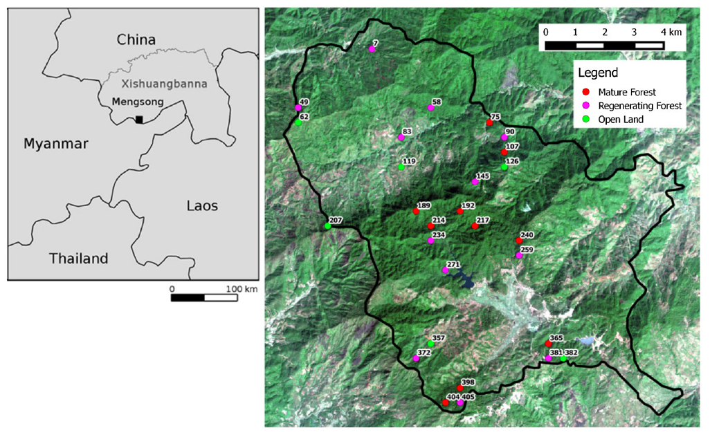
Appendix A. Study site location, sample sites selection and plot design.
Our research was conducted in Mengsong, Xishuangbanna, China (UTM/WGS84: 47 Q 656355 E, 2377646 N, 1100-1900 m asl, Fig. A1).
To obtain an unbiased selection with sample plots of different degradation status distributed across the landscape, we derived plot locations by applying double sampling with stratification. A 500×500 m grid of points was placed over a remotely sensed image (SPOT 5 acquired in Oct 2009) of the landscape and each point was classified by eye as mature forest, regenerating forest, or open land. Approximately 10% of the points were ground-truthed to verify our classification and adjustments were made accordingly. Points were accepted as being mature forest if the site was dominated by large (>30 cm dbh) trees with no evidence of recent disturbance (stumps or visible char on trunks). Forests dominated by smaller trees or with signs of recent disturbance were classified as regenerating forest. Most of these were young successional seres re-growing from slash-and-burn, although some were older forests that were highly disturbed, for example, through cultivation of tea in the understorey. Open land points included grasslands and terraced tea fields, with few or no trees. Points landing on water bodies, within villages and within a small area of paddy field next to the largest village were removed from the selection. In addition, we removed points that fell on the boundary between land-cover categories, so that our sample plots could be unambiguously assigned to a single category. Next, we divided the landscape into 16 compact equal-area units from which 12 were randomly selected for sampling, and we selected points within these units using a random number generator. We selected a mature and regenerating forest point in each of the 12 units, although two of the units did not have any mature forest. Open land points were selected from every second unit, because it was expected that these would be more self-similar and hence require a lower level of replication for our biodiversity studies. Thus, the process resulted in a final selection of 10 mature forest points, 12 regenerating forest points and six open land points (Fig. A1).
Table A1. Summary results of plot characteristics. Forest type was assigned a priori based on interpretation of satellite images (SPOT 5 acquired in Oct 2009) with ground truthing for ~ 10% of points. Basal area of the plot was calculated based on all tree species with >2 cm dbh summed across nine sub-plots (combined area = 0.28 ha). Canopy openness was estimated from hemispherical photographs taken in the center of each sub-plot and averaged across all nine sub-plots (Beckschäfer et al. 2014). Historical land-use and forest age were derived from key informant interviews and only information from people familiar with the actual plot sites were used. Dominant species given are the three species with the highest basal area (trees with >10 cm dbh) in each plot.
Plot no. |
Forest type |
Basal area (m² ha-1) |
Canopy openness (%) |
Historical land used type |
Forest age |
Dominant species |
7 |
Reg. Forest |
13.4 |
14.1 |
Swidden and upland rice plantation |
~30 |
Schima wallichii, Castanopsis mekongensis, Betula alnoides |
49 |
Reg. Forest |
19.7 |
9.7 |
Sparse woodland with grazing until 1982 |
~30 |
Castanopsis mekongensis, Castanopsis calathiformis, Schima wallichii |
58 |
Reg. Forest |
26.0 |
4.5 |
Swidden and rice plantation/grazing |
43 |
Betula alnoides, Schima wallichii, Litsea martabanica |
62 |
Open land |
0.0 |
60.7 |
Grassland with grazing until now |
0 |
Imperata cylindrica grassland with Rubus spp. bushes |
75 |
Mature forest |
23.1 |
4.4 |
Pine forest was cleared at 1972 and upland rice plantation for a year and then abandoned |
38 |
Schima wallichii, Alseodaphne andersonii, Machilus tenuipilis |
83 |
Reg. Forest |
22.2 |
4.9 |
Swidden and upland rice plantation in 1980s |
~20 |
Schima wallichii, Castanopsis mekongensis, Helicia tsaii |
90 |
Reg. Forest |
21.1 |
5.2 |
Woodland with grazing until 1980s |
~20 |
Metadina trichotoma, Balakata baccata, Betula alnoides |
107 |
Mature forest |
26.6 |
3.9 |
Forest with large scale logging in around 1974 followed by upland rice plantation until 1978 |
>33 |
Schima wallichii, Betula alnoides, Castanopsis mekongensis |
119 |
Open land |
0.0 |
71.4 |
Grassland followed by upland rice plantation/grazing until 2000 and tea plantation in 2001 |
0 |
Tea plantation, no trees occur |
126 |
Open land |
2.3 |
52.3 |
Sparse woodland with upland rice cultivation/grazing. Cleared remaining forest in 2006/2007 for tea plantation |
0 |
Tea plantation with sparse trees of Castanopsis mekongensis, Castanopsis calathiformis, Betula alnoides |
145 |
Reg. Forest |
21.4 |
6.0 |
Forest with timber extraction and grazing |
~28 |
Schima wallichii, Betula alnoides, Castanopsis fleuryi |
189 |
Mature forest |
27.8 |
4.2 |
Grassland with grazing |
>50 |
Castanopsis mekongensis, Betula alnoides, Lithocarpus truncatus |
192 |
Mature forest |
27.3 |
4.6 |
Forest |
>50 |
Castanopsis mekongensis, Anneslea fragrans, Magnolia floribunda |
207 |
Open land |
3.3 |
52.8 |
Grassland with frequent burning until now |
0 |
Imperata cylindrica grassland with sparse trees of Castanopsis calathiformis, Heliciopsis terminalis, Meliosma sp. |
214 |
Mature forest |
43.6 |
3.1 |
Forest with Amomum tsaoko plantation on floor until 1990s |
>50 |
Beilschmiedia robusta, Magnolia floribunda, Eurya pittosporifolia |
217 |
Mature forest |
22.8 |
5.6 |
Forest with Amomum tsaoko plantation on floor until 1990s |
>50 |
Alangium kurzii, Cryptocarya brachythyrsa, Lithocarpus microspermus |
234 |
Reg. Forest |
21.8 |
3.8 |
Forest with logging followed by partially bamboo plantation and limited tea trees. |
~20 |
Castanopsis calathiformis, Litsea martabanica, Schefflera bodinieri |
240 |
Mature forest |
33.8 |
3.8 |
Forest with rattans extraction during 1980s |
> 50 |
Castanopsis calathiformis, Schima wallichii, Castanopsis mekongensis |
259 |
Reg. Forest |
19.9 |
14.0 |
Forest with understory tea cultivation since at least 1940 |
NA |
Castanopsis mekongensis, Schima superba, Castanopsis calathiformis |
271 |
Reg. Forest |
8.5 |
5.8 |
Frequent logging until now with tea plantation under trees in a part of the plot in 2009 |
~15 |
Schima wallichii, Eurya groffi, Juglans regia |
357 |
Open land |
2.9 |
55.3 |
Upland rice and corn plantation/grazing until 1982 followed by terrace tea and walnut plantation in 2001. |
0 |
Tea plantation with sparse trees of Engelhardia spicata, Macaranga indica, Saurauia napaulensis |
365 |
Mature forest |
27.1 |
4.2 |
Forest with sparse timber extraction and grazing until 2006 |
> 50 |
Archidendron kerrii, Cryptocarya yunnanensis, Nephelium chryseum |
372 |
Reg. Forest |
29.6 |
5.9 |
Swidden and corn plantation until 1982 |
29 |
Macaranga indica, Lithocarpus fenestratus, Xanthophyllum yunnanense |
381 |
Reg. Forest |
14.7 |
4.4 |
Swidden and upland rice plantation until 1985 |
26 |
Eurya groffi, Engelhardia spicata, Garcinia cowa |
382 |
Open land |
5.6 |
40.2 |
Swidden and rice plantation until 2002. Tea plantation in 2006. |
0 |
Tea plantation with sparse trees of Eurya groffi, Saurauia napaulensis, Kydia calycina |
398 |
Mature forest |
30.6 |
4.5 |
Forest with timber extraction and grazing. Burnt twice during 1980s. |
> 50 |
Dysoxylum excelsum, Pyrenaria diospyricarpa, Magnolia xanthantha |
404 |
Mature forest |
35.9 |
4.3 |
Forest with grazing until 1985 |
> 50 |
Macaranga indica, Magnolia floribunda, Stereospermum tetragonum |
405 |
Reg. Forest |
20.6 |
7.0 |
Grassland with grazing until 1980s |
~20 |
Macaranga indica, Meliosma wallichii, Schefflera bodinieri |
Fig. A1. Study site location: Mengsong, Xishuagbanna, southern Yunnan, China. Colored dots represent the location of plots and forest type. The numerals besides the dots represent the plot number as given in Table A1.
Literature cited
Beckschäfer, P., L. Fehrmann, R. D. Harrison, J. Xu, and C. Kleinn. 2014. Mapping leaf area index in subtropical upland ecosystems using RapidEye imagery and the randomForest algorithm. iForest 7:1–11.