Ecological Archives C006-084-A2
K. M. Proffitt, J. F. Goldberg, M. Hebblewhite, R. Russell, B. S. Jimenez, H. S. Robinson, K. Pilgrim, and M. K. Schwartz. 2015. Integrating resource selection into spatial capture-recapture models for large carnivores. Ecosphere 6:239. http://dx.doi.org/10.1890/es15-00001.1
Appendix B. Validation of the mountain lion resource selection model in the Garnet and Bitterroot study areas.
Methods
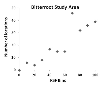
To assess how well predictive maps of lion resource selection fit lion distributions within each study area, we used the location of hunter-harvested mountain lions to validate the mountain lion predictive resource selection function (RSF) map. In the Bitterroot study area, we used harvest location data from 1996–2003 and 2007–2011. Data from 2003–2007 were not available. We classified pixels of the predictive map into 10 equal-interval RSF intervals that correspond to the relative probability of use. We extracted the RSF value for each harvest location and counted the number of harvested lions within each RSF interval. To evaluate the relationship between counts of harvest locations and RSF bins, we used a Spearman’s rank test.
Results
In the Bitterroot study area, 218 mountain lion harvest locations were used to validate the RSF model. The Spearman’s rank correlation coefficient was 0.87, p = 0.0009.
Fig. B1. The number of harvested mountain lion locations within each of the 10 equal-interval RSF intervals that correspond to the predicted relative probabilty of mountain lion use.