Ecological Archives E096-078-A2
Alicia M. Wilson, Tyler Evans, Willard Moore, Charles A. Schutte, Samantha B. Joye, Andrea H. Hughes, and Joseph L. Anderson. 2015. Groundwater controls ecological zonation of salt marsh macrophytes. Ecology 96:840–849. http://dx.doi.org/10.1890/13-2183.1
Appendix B. Hydraulic gradients from the Cabretta Island and Crabhaul Creek salt marshes.
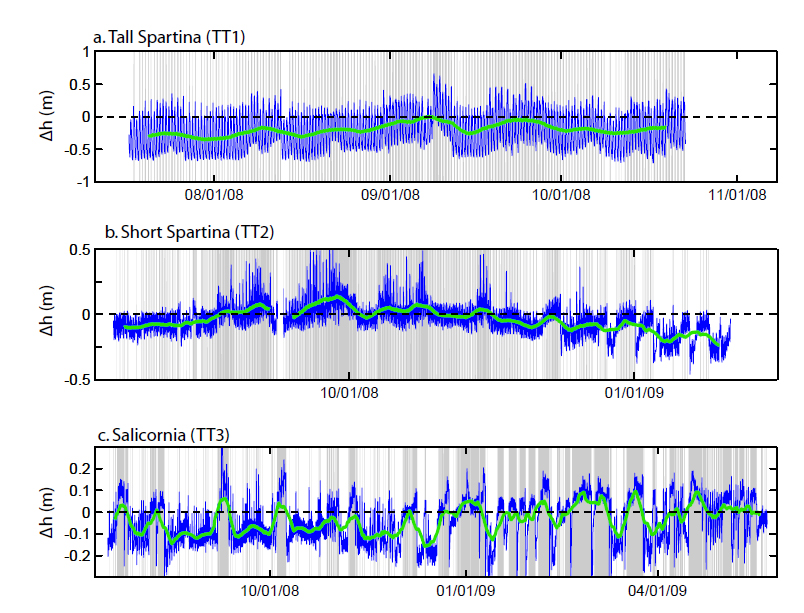
Fig. B1. Differences in hydraulic head between the 1 m and 2.5 m wells at Cabretta Island for the entire observation period. (a) Tall Spartina zone. (b) Short Spartina zone. (c) Salicornia zone. Blue line is Δh, which is proportional to the vertical component of groundwater velocity, calculated at 20-minute intervals. Positive Δh and gray shading indicate upward flow. Green line is a 14-day running average of Δh. Note different y-axis scale in (a).
Fig. B2. Differences in hydraulic head between the 0.6 m and 1.2 m wells at Crabhaul Creek. (a) Medium Spartina zone. (b) Short Spartina zone. (c) Salicornia zone. (d) Juncus zone. Blue line is Δh, which is proportional to the vertical component of groundwater velocity, calculated at 15-minute intervals. Positive Δh and gray shading indicate upward flow. Green line is a 14-day running average of Δh. Note different y-axis scale in (a).
Fig. B3. Inundation frequency at Crabhaul Creek for the (a) short Spartina zone (b) Salicornia zone and (c) Juncus zone. Blue line is the water level in Crabhaul Creek. Green line indicates the elevation of the marsh at the well. Gray shading indicates upward groundwater flow, as in Fig. 3. The short Spartina zone was inundated on almost every tidal cycle. The Salicornia zone was inundated during spring high tides, and significant upward flow occurred during periods when the Salicornia zone was not inundated. The Juncus zone was inundated very rarely, so very little saline water infiltrated. Thus periods of upward flow indicate discharge of fresh water.