Ecological Archives E096-068-A3
Stephen J. Murphy, Lívia D. Audino, James Whitacre, Jenalle L. Eck, John W. Wenzel, Simon A. Queensborough, and Liza S. Comita. 2015. Species associations structured by environment and land-use history promote beta-diversity in a temperate forest. Ecology 96:705715. http://dx.doi.org/10.1890/14-0695.1
Appendix C. Soils Survey Data.
Table C1. Description of the 21 soil types found at Powdermill Nature Reserve, obtained from publicly available survey records. Typical physical and chemical properties for each soil type are shown, and were obtained from detailed descriptions of the soil types available from the web soil survey (NRCS 2013).
Soil Type |
Description |
% Blocks |
Slope (%) |
Depth to Water Table (m) |
Bulk Density* |
%Sand |
%Silt |
%Clay |
pH |
C.E.C† |
A.W.C‡ |
Organic |
BeD |
Bethesda very channery silt loam |
1.6 |
8 to 25 |
> 200 |
1.48 |
26.0 |
53.0 |
21.0 |
4.6 |
NA |
0.13 |
0.25 |
BuB |
Buchanan loam, extremely stony |
13.0 |
0 to 8 |
50 |
1.30 |
27.3 |
54.7 |
18.0 |
4.5 |
17 |
0.15 |
2.50 |
BuD |
Buchanan loam, extremely stony |
8.0 |
8 to 25 |
50 |
1.30 |
27.3 |
54.7 |
18.0 |
4.5 |
17 |
0.15 |
2.50 |
CaB |
Cavode silt loam, very stony |
1.0 |
3 to 8 |
35 |
1.30 |
18.0 |
57.0 |
25 |
5.0 |
20 |
0.20 |
3.00 |
CeB |
Cavode silt loam, very stony |
1.9 |
0 to 8 |
35 |
1.30 |
18.0 |
57.0 |
25 |
5.0 |
20 |
0.20 |
3.00 |
CrB |
Craigsville-Buchanan complex, extremely stony |
1.2 |
0 to 8 |
> 200 |
1.30 |
66.6 |
23.4 |
10.0 |
5.1 |
10 |
0.09 |
3.00 |
ErB |
Ernest silt loam |
3.3 |
3 to 8 |
53 |
1.30 |
27.3 |
54.7 |
18.0 |
5.4 |
21 |
0.17 |
3.00 |
GcB |
Gilpin channery silt loam |
2.1 |
3 to 8 |
> 200 |
1.30 |
26.3 |
52.7 |
21.0 |
5.8 |
15 |
0.17 |
2.25 |
GcC |
Gilpin channery silt loam |
0.4 |
8 to 15 |
> 200 |
1.30 |
26.3 |
52.7 |
21.0 |
5.8 |
15 |
0.17 |
2.25 |
GcD |
Gilpin channery silt loam |
1.0 |
15 to 25 |
> 200 |
1.30 |
26.3 |
52.7 |
21.0 |
5.8 |
15 |
0.16 |
2.25 |
LaD |
Laidig gravelly loam, extremely stony |
3.9 |
8 to 25 |
76 |
1.30 |
43.3 |
39.7 |
17.0 |
4.5 |
15 |
0.10 |
3.00 |
LaE |
Laidig gravelly loam, extremely stony |
4.3 |
25 to 35 |
76 |
1.30 |
43.3 |
39.7 |
17.0 |
4.5 |
15 |
0.10 |
3.00 |
MaF |
Macove-Gilpin channery silt loam, extremely stony |
10.3 |
35 to 75 |
> 200 |
1.30 |
29.3 |
53.7 |
17.0 |
5.0 |
28 |
0.11 |
1.50 |
MkF |
Mechesville channery silt loam, extremely stony |
0.2 |
25 to 70 |
76 |
1.20 |
27.3 |
54.7 |
18.0 |
5.2 |
NA |
0.14 |
2.50 |
RgB |
Rayne channery silt loam, very stony |
9.5 |
0 to 8 |
> 200 |
1.30 |
27.3 |
54.7 |
18.0 |
5.0 |
16 |
0.14 |
2.50 |
RgD |
Rayne channery silt loam, very stony |
10.1 |
8 to 25 |
> 200 |
1.30 |
27.3 |
54.7 |
18.0 |
5.0 |
16 |
0.14 |
2.50 |
WrB |
Wharton silt loam |
6.4 |
3 to 8 |
46 |
1.20 |
22.5 |
57.5 |
20.0 |
5.4 |
22 |
0.18 |
2.50 |
WrC |
Wharton silt loam |
4.3 |
8 to 15 |
46 |
1.20 |
22.5 |
57.5 |
20.0 |
5.4 |
22 |
0.18 |
2.50 |
WsB |
Wharton silt loam, very stony |
9.1 |
0 to 8 |
69 |
1.20 |
26.5 |
53.5 |
20.0 |
5.4 |
22 |
0.18 |
2.50 |
WsD |
Wharton silt loam, very stony |
8.0 |
8 to 25 |
69 |
1.20 |
26.5 |
53.5 |
20.0 |
5.4 |
22 |
0.18 |
2.50 |
*measured as soil dry weight divided by total volume of the sample
† Cation exchange capacity (cmolc/kg soil)
‡ Available water capacity
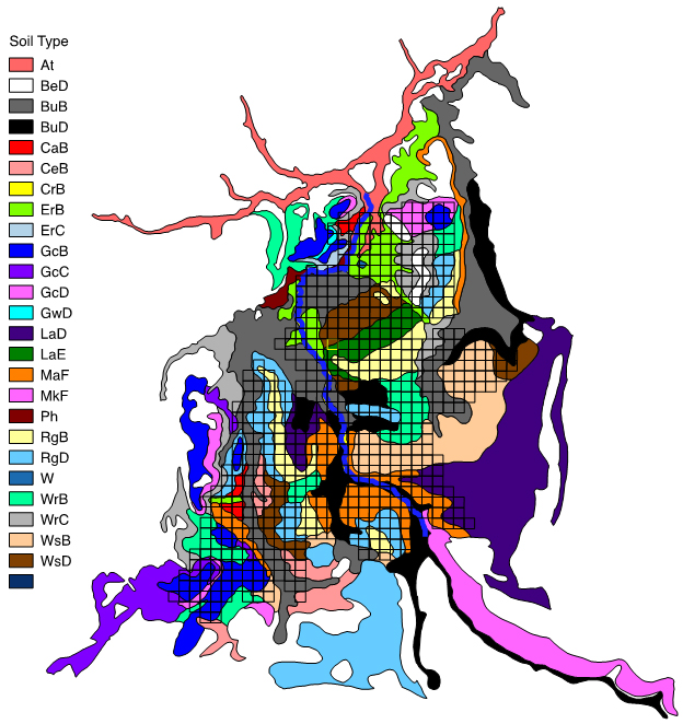
Fig. C1. Soil map associated with the area surrounding Powdermill Nature Reserve. Colored polygons indicate soil types. The vegetation survey grid is shown in black. See Table C1 for a description of each soil type.
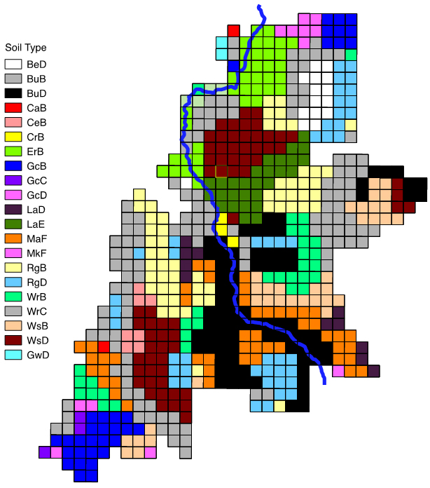
Fig. C2. Soil map for Powdermill Nature Reserve at the block scale. Soil types for individual blocks were obtained by merging the soil survey map in Fig. C1 with the plot layout design for the vegetation survey (Appendix A). These data were used in variation partitioning model and the multivariate regression tree analysis.